On the island of Faial in the Azores archipelago is a distinctive hike from the top of the island to the bottom called the Trail of Ten Volcanoes. The Azores, a volcanic island chain in the Atlantic Ocean is a semi-autonomous part of Portugal. I was staying in the primary city of the island at an Air BnB called Banana Manor. There was one other guest at the time, a young guy from Stuttgart named Mo who was also interested in this hike so we teamed up on a cab to the trailhead and spent the day together on an excellent hike.

I was coming to Faial from Santa Maria island where I had done a multi-day trek on the Grand Route of Santa Maria (read the story of the trek here). I also hiked on Sao Miguel and Pico Islands during the visit to the Azores, and I would love to go back and hike more of the islands for sure. For this day though, it was Faial and a spectacular hike that went up, down, and around a chain of ten volcanoes from the highest mountain on the island down nearly to sea level.
Mo and I called a taxi for pick-up and we were promptly picked up by Tony, an amusing and talkative driver who became or regular driver while on Faial. Like many people of the Azores that I encountered, Tony spoke pretty good English and he keeps good track of what is going on in the world. It was about a half-hour drive from the port town of Horta up-and-up to where the road ends just below the rim of the volcano mountain called Caldeira. As we were ascending into a cloud that was nearly obscuring the mountain-top I thought I heard Tony say, “there is flamingos.” It turned out not to be pink birds though, but instead the community of Flamengos. Flamengos refers to Flemish (Belgian) people who were early settlers in this area. Before we knew it, we were dropped off at the trailhead and we arranged to call Tony for a ride when we finished the hike.


The total route of the Trail of Ten Volcanoes is about 12 miles (20 km) and starts at 3000 feet (918 m) altitude. The descent drops to the lighthouse and museum at Capolinhos which are nearly at sea level. It isn’t all downhill, though. There are a bunch of volcanos in the way so there is a good bit of up and down. My GPS measured about 1500 feet (450 m) of climbs with grades up to 5%. I wouldn’t call this a beginner’s hike.
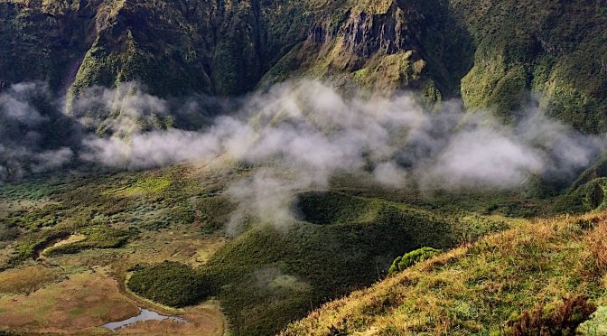
Breaking over the rim of Caldeira there is a spectacular view down into the cone. Rim-to-rim must be two-thirds of a mile in diameter. It is so big that I cannot capture a complete view even with a wide-angle lens. A small cone rises out of the floor of the caldera where there are also small lakes. Our route traverse part way around the rim for about 2.5 miles (4 km) before beginning a descent down a volcanic ridge to the West. There is still a scattering of clouds although the sun is beginning to burn them off.


A section of the route called Levada (aquaduct) follows an old water supply channel in a thick stand of cedar and juniper. As I understand it, the function of this levada was interrupted by an earthquake in the late 1990’s.


The route passes through the Capelo Forest Park, an area of thick forest and some interesting old structures. It looks like a fine place for a picnic. Leaving the park we started climbing the slope of yet another volcano.

The last volcano we approached is called Capelinhos. It is notable as the most recently formed volcano in the Azores and it can be considered the farthest West point in Europe. Here is a description from Wikipedia: “the volcanic eruption (partially submarine) lasted for 13 months, from September 27, 1957 until October 24, 1958. While enlarging the island by 2.4 km², it spawned 300 seismic events, hurled ash 1 km, destroyed 300 houses in the parishes of Capelo and Praia do Norte and caused the evacuation of 2,000 people – many to the U.S. and Canada.”

There is an old lighthouse at Capelinhos that was rendered useless by the eruptions. When at Capelinhos you are standing on some of the youngest land in the world. At this site is also a visitor center and museum that tell the story of the volcano. After looking around a bit, Mo called Tony and after a quick ride back to Horta along the coast it was time for a well-deserved beer.


Leave a Reply