 The San Pedro Parks Wilderness, located in the Jemez Mountains of North-Central New Mexico is 40,000+ acres of remote country … much of it at altitudes exceeding 10,000 feet (3048 m). The nearest town and easiest access is from the town of Cuba to the west. This wilderness is administered by the U.S. Forest Service’ Santa Fe National Forest. There are multiple trails that criss-cross the area and we found that the signage that exists on the ground did not necessarily match the labeling on our topo map.
This is a 15 mile (24.57 km) hike round-trip . The hike has a total ascent of 1520 feet (464.19 m) and has a maximum elevation of 10,340 feet (3,153 m). In fact, a good bit of the hike is at altitude exceeding 10,000 feet. This can be done as a long day hike, but I did this as a two night backpacking trip with my sons. We hiked in on a Friday evening, set up a base camp in a beautiful spot, then day-hiked a big loop on Saturday before hiking out on Sunday morning.

This area takes some getting to. The easiest access is to come to Cuba, NM then find State Highway 126 in the village which heads east and climbs into the Jemez Mountains. Cuba is a pleasant little village on the major highway (US 550) connecting Albuquerque to Farmington. It is about 18 miles (imprecise) on this paved road to the turn-off to the trailhead. The turn-off onto route 70 is well marked as the route to San Gregorio Lake. There is a parking area with restrooms at the trailhead.
You can also approach from the east on State Highway 4, then 126, which is a shorter drive if you are coming from Santa Fe or Los Alamos. Beware that 20 miles or so of 126 beginning soon after Fenton Lake is unpaved, windy, mountain road so is slow going and not recommended if there has been recent rain or snow.

San Gregorio Lake appears to be a popular fishing place and hang out by the water place for locals, so the trailhead can have plenty of activity and the segment of trail to and from the lake is where we saw any other people. Beyond the lake we encountered only one or two other people during our hike. The following map shows the route we followed and some of the main trail intersections on the route. We found that the names on signs on the trails (where they existed) did not always match the names of the trails printed on the topo map so beware of that. The Damian Trail does not appear on the map, but I assure you it is there on the ground. The Forest Service has a very weak map posted at the trailhead that gives route numbers rather than route names … we never saw a route number posted on any trail signage during our hike so that wasn’t too helpful. Trail signage was sporadic anyway, so nothing you want to heavily rely on. A main wayfinding feature on the route are big wooden posts that dot the landscape in many of the meadows. These are designed to give a visual cue as to the trail direction when you look across the big expanses of meadow. They are fairly frequent, but some meadows have them and others don’t so again, don’t get too reliant on them.


San Pedro Parks is an absolutely appropriate name as the route takes you through huge, park-like meadow after meadow that are just plain gorgeous. When not crossing a meadow, you pass through aspen, fir, and spruce forest. We did this trip in June … before the summer rains … and there was plenty of water in the streams and the meadows were lush with tall grasses and flowers. We made our camp at a beautiful spot an appropriate distance from the Rio Puerco.


Lots of carvings in the aspen bark … particularly on the trail between the parking area and the lake.

no camping at the lake … day use only — I guess campers might disturb the cattle that hang out at the lake. As a wilderness, cows seem to be ok but no bikes or machines allowed.


Rio Puerco — we could see small trout in stream.


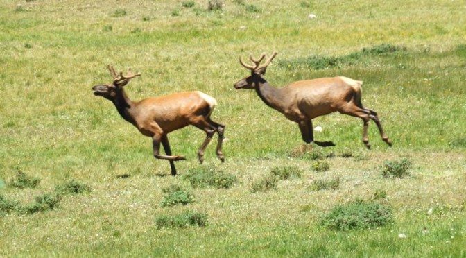
While eating lunch up on a hill overlooking one of the meadows, a group of five elk came thundering out of the woods and across the meadow. Two young ones stayed in the meadow a bit playing with each other.


Our crew on the morning of the hike out


You pass through some serious old forest on this hike


Leave a Reply