

The best I can tell with very limited Spanish abilities is that Cerros Del Abrigo translates to either “coat hills” or “shelter hills”. Shelter sounds more intuitive to me in this application and peaking at more than 10,000 feet, this is certainly more a mountain than a hill, so I’m going to translate it as Shelter Mountain until someone who knows better corrects me.
 Cerros Del Abrigo is one of several volcanic domes that have risen from the floor of the Valles Caldera a collapsed bowl of a super volcano that erupted more than a million years ago. In just the past decade or so the Valles Caldera National Preserve (read more here) was formed and the land within is becoming increasingly accessible to the public.
On the Friday morning that I hiked here, I was the only human on the mountain. The options for hiking in the 89,000 acre preserve are not yet widely known and understood, so it is a great time to visit for those who enjoy solitude in an environment of incredible scenic beauty. The Abrigo Trail is one of a dozen or so trails available for hiking on the preserve. (Read my story about the Redondito hike here.) The trailhead is reached by a 20-30 minute van ride from the visitor center at the Preserve’s “staging area”. The vans operate in the summer on Fridays through Mondays starting at 8:30 in the morning through the late afternoon. The vans operate on a loop and a van passes any given point on the loop about once per hour to pick up and drop people off.
 The trail for this hike is called the Abrigo Trail which starts in a meadow, climbs the Southwest side of Cerros Del Abrigo, then traverse the mountain in a counter-clockwise direction (nothing prevents going either direction, but the trail markers are set up to make the route easier to follow by going counter-clockwise). The hike is about a seven miler (11.2 km) with a starting altitude of 8700 feet (2657 m). The route tops out at 9670 feet (2948 m). Cerros Del Abrigo is circled by a bunch of old logging roads (used decades ago) at varying altitudes and the Abrigo Trail makes use of these to climb and then circle the mountain on a high line. (Clicking on the route map above will take you to an interactive map on mapmyhike.com that allows you to locate this hike in NM and the world, provides additional hike data, downloadable .gpx and .kml. and even has a widget that let’s you “fly” the hike route in Google Earth.)
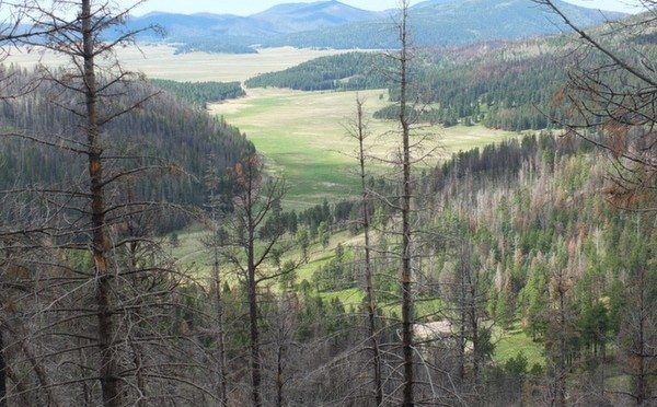
 There are great panoramic views throughout the route and you eventually get a look in every direction as you circle the peak. A good deal of the hike passes through areas burned in the Las Conchas wildfire in 2011. The trail is notched into very steep terrain on the east side of the mountain, and you will encounter several relatively small rockslides that have dumped rocks across the path. None of these slide areas took long to cross or felt treacherous in any way. You just have to step from rock to rock in places and be sure that you are stepping on stationary rock or earth as you go. In late May the aspens were beginning to leaf, there were lots of flowers out, and I encountered multiple groups of elk along the way. I’ll let pictures tell the rest of the story …
Beginning of the trail


Aspens filling into burned area … many are chest high three years after the burn


Redondo Peak and Redondito in the distance. Read about my Redondito hike


End of the hike

Leave a Reply