
 The terrain gets exciting fairly quickly as I start an early morning drive south from Alpine, TX. I am heading for the big bend in the Rio Grande in Southwestern Texas — Big Bend National Park. This is as mountainous as you get in Texas. The elevation at the Park ranges from 1800 feet (550m) at the Rio Grande to 7830 feet (2390m) on top of Emory Peak, the highest in the Chisos mountain range.
 Big Bend is a hiker’s paradise containing the largest expanse of roadless public lands in Texas. There are more than 150 miles ( km) of trails in the Park that are used both for hiking and backpacking. There are 21 “official” trails, the longest of which is about a 15 mile (24km) out-and-back route. There are several opportunities for creating loops — particularly in the Chisos Basin part of the Park.

The first of two dayhikes I took was a route called “Lost Mine Trail”. About five miles (8km) in and out, the “in” climbs steadily up the mountainside below Casa Grande Peak into a boxed off canyon. Eventually there is a pass where you cross a divide into Juniper Canyon then immediately face a series of switchbacks that climb to the ridge above. When you reach the ridge, the rest of the climb is up the ridge line to some big, barren rocks above. The altitude over the hike ranges from about 5800 (1770m) to 6800 feet (2070m).

The plant life consists of mixed juniper, oak, and pine forest with the pines getting bigger of course the higher up you go. Closer to the ground are lots of cactus, agave, and colorful flowers. It’s a beautiful hike offering both close-up interest (plants and critters) as well as sweeping panoramas. I didn’t pass any sign of a mine, but I figure it’s lost somewhere up there. Following are images from the hike to give you a sense of what it looks like in the mountain area of the Big Bend. Captions, when provided precede the related image.


 Some of the sparse shade to be found along the Lost Mine Trail …

 Masses of bugs traveling on an Agave …
 Casa Grande Peak

 A view down Juniper Canyon …

 Snaky looking lizard …
 Lots of partially eaten cactus fruit on the trail … javelinas?

 Casa Grande Peak


 Ridgeline …


 At the top …


 Back down the way I came …
 Big Bend Park is huge covering more than 800,000 acres and can be approached from several directions. As a result, there are multiple visitor centers. At Chisos Basin there is a visitor center and small commercial area with a post office, store, lodge, restaurant, and bar. I got good help there with scoping out a place out in the desert to camp and catch the sunset.

 A cold Tejas lager (bought from the Park store) at sunset … the camping site I chose was primitive and I was all alone out there …


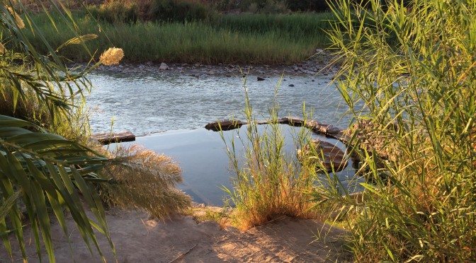
 In the morning I made my way down to the Rio Grande to find the start of my second day hike …
 The village of Boquillas, Coahuila, Mexico is just across the river. I did not go over but I understand there is a border crossing that is open during the day Wed-Sun. The village reportedly has about 200 residents and two restaurants that mostly cater to tourists who come across.
 My second day hike was to take the Hot Spring Canyon Trail to Lambert Hot Springs for an early morning soak. This is a 6+ mile (11+km) “there-and-back” route that generally follows the Rio Grande but does dip up into the occasional side canyon.


 Ruins of the hot spring resort …


 Bird nests in the cliffs along the river …
 The hot spring is contained by the foundation walls of the bath house ruin. The cold river runs right alongside. The springs are shallow, but a good soak at 105 degrees F (40.5C) …


 I left by way of Terlingua, a tiny but colorful and photogenic “ghost” town to the North. Not really unihabited, but didn’t see many people …


Leave a Reply