,

Island Trek in the Azores

AzoresIslandTrek - DSCF9011.jpg

“To awaken in a strange town is one of the pleasantest sensations in the world” — Freya Stark

I wake up to the sound of the surf — waves crashing on rocks somewhere outside my window.  As I come out of my dream state I remember that today is a day for walking.  Not just any walk at that — the Grand Route of Santa Maria Island in the Azores is in my sights for the next five days.  The “Grande Trilho Santa Maria” is about 80 kilometers (50 miles) of walking around the circumference of the island with a hike up over the highest peak on the island, Pico Alto, thrown in for good measure.

AzoresIslandTrek - grandroute2.jpg
Santa Maria Island and the Grand Route trek – click to view larger

Santa Maria is geologically the oldest of the nine islands that make up the Azores archipelago in the Atlantic Ocean.  Multiple volcanic eruptions combined with the natural processes of the ocean over the eons caused Santa Maria to rise out of the water multiple times — there are both lava fields and fossil deposits here.

AzoresIslandTrek - azoresmap-1.jpg
Location and islands of the Azores

The Azores are located more than 1300 km (850 miles) West of their Portuguese motherland and served as an outpost and resupply point servicing the explorations of the New World in the 1400’s.  Surprisingly, the Azores are only about a four-hour direct flight from Boston and two to three hours from some European cities.  In the early years of trans-Atlantic flight and through World War II, the islands’ placement was important for refueling and strategic purposes.  Santa Maria had a population of about 15,000 back when the US military operated here but now is home to about 5000 people.

AzoresIslandTrek - DSCF9003.jpg
The main street in Vila do Porto

Over coffee in Vila do Porto, the principal town on the island, I get a good orientation to the Grand Route from Ioannis and Rita Rousseau, proprietors of a small business here called Ilha a Pe (meaning ‘island on foot”).  They tell me how to recognize the route markings, where there are services along the way, highlight some of the sights and points of interest I will pass, and — importantly — how to find the series of eco-cottages they have established and maintain along the way.  I will stay at a different one of these the next four nights to break the trek into five days of walking.

AzoresIslandTrek - DSCF9014.jpg
The Grand Route trail markers use a white and red stripe. If the route is also part of a shorter local route or loop, it also is marked with a yellow stripe for that segment.

Ilha a Pe’s facilities and services mean that I will only need to carry a daypack.  Ioannis will bring my luggage & a sleeping bag along with dinner and breakfast each night to where I am staying that night.  They have things set up so that you can backpack and take care of your own food at a lower price, but I found their service to carry my stuff and bring meals to be well worth the price.  I think that at the time of my trip, the “backpackers” price for just a place to stay for the four nights (no meals or moving your stuff) was about 120 euros and it was only another 80 euros to add meals and moving your stuff (check their website for current pricing).  An excellent value I think.

Day 1

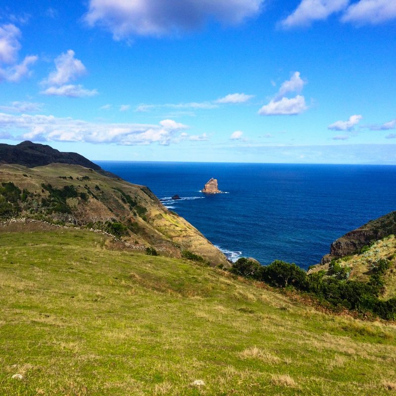
The couple points the way and I am off heading east along the Southern coast of the island.  The coastline here is fairly open country on top of high bluffs overlooking the Atlantic.  Soon, roads through farmlands transition to a narrower trail close to the precipice of the bluffs.

AzoresIslandTrek - DSCF9040.jpg
AzoresIslandTrek - DSCF9041.jpg
A cave along the route
AzoresIslandTrek - DSCF9016.jpg
I visited during October — well off prime time for flowers in the Azores. I understand that the summer wildflower displays are spectacular. Even so, there were still plenty of beautiful flowers along the way
AzoresIslandTrek - DSCF9051.jpg
AzoresIslandTrek - DSCF9058.jpg
AzoresIslandTrek - DSCF9032.jpg
a traditional way of stacking corn stalks to dry
AzoresIslandTrek - DSCF9022.jpg
AzoresIslandTrek - DSCF9065.jpg
AzoresIslandTrek - DSCF9028.jpg
AzoresIslandTrek - DSCF9067.jpg
AzoresIslandTrek - DSCF9068.jpg
AzoresIslandTrek - DSCF9072.jpg
AzoresIslandTrek - DSCF9073.jpg
AzoresIslandTrek - DSCF9076.jpg
AzoresIslandTrek - DSCF9054.jpg
AzoresIslandTrek - DSCF9085.jpg
In places, the path passes through dense stands of bamboo
AzoresIslandTrek - DSCF9093.jpg
The architecture of the island features distinctive chimneys that look like towers
AzoresIslandTrek - DSCF9097.jpg

Different colors are used on the traditional homes in the different parts of the island — blue, yellow, green and reddish (like clay pottery.

AzoresIslandTrek - DSCF9100.jpg
AzoresIslandTrek - DSCF9082.jpg
AzoresIslandTrek - DSCF9104.jpg
AzoresIslandTrek - DSCF9107.jpg
AzoresIslandTrek - DSCF9113.jpg
house at Malbusca
AzoresIslandTrek - DSCF9116.jpg
Ilha a Pe eco-cottage near Malbusco

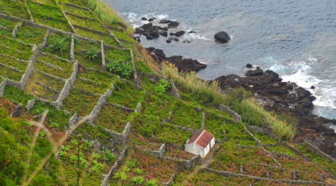
Ilha a Pe’s eco-cottages are renovated stone farm sheds.  All of them are located at spectacular scenic settings.  Ioannis and Rita told me about their experiences with acquiring and renovating these properties.  It wasn’t always easy as the concept they were working on was like nothing the local authorities and regulators had ever encountered.

I arrived in the mid-afternoon and took a walk over to a small shop at Malbusca and did some writing while sitting in the sun with a cold drink.  Ioannis arrived soon after I returned to the eco-cottage to drop off my stuff and bring me dinner and the next day’s breakfast.  Rita had prepared a great, traditional feast for me — squid stew, rustic bread, and tremocos (lupini beans) in locally crafted pottery.  I enjoyed all of the meals throughout the trek — there were interesting local specialty treats each day … some I remember were biscoitos de orelha (ear cookies), a homemade pate, and a homemade cheese.

AzoresIslandTrek - DSCF9128.jpg
AzoresIslandTrek - DSCF9130.jpg
squid stew
AzoresIslandTrek - IMG_0784.jpg
AzoresIslandTrek - DSCF9135.jpg
cottage view

The eco-cottages are spartan, but nicely equipped and appointed.  Each one is set up with bunks to accommodate six people.  A solar cell provides electricity for lights (no wall outlets) and a solar hot water set-up provides hot water for showers and washing up.  A composting toilet set-up handles bathroom needs.  A wood burning stove is available for warmth, but it was never cold enough (I visited in October) that I wanted to use one.  A propane stove is available to heat food and water for coffee.  I found the eco-cottages all to be relaxing and comfortable places to stay.

AzoresIslandTrek - IMG_0788.jpg
AzoresIslandTrek - DSCF9137.jpg
Malbusca eco-cottage view to the sea
AzoresIslandTrek - DSCF9138.jpg
Guests are expected to clean up after themselves and leave the eco-cottages as they found them.

Day 2

Breakfasts typically consisted of coffee (others may prefer tea) bread, butter, jam, cheese, sliced deli meat, yogurt, fruit, hard boiled egg … a plentiful continental breakfast.  After breakfast and a bit of clean-up it was back on the trek.

AzoresIslandTrek - IMG_0764.jpg
AzoresIslandTrek - DSCF9098.jpg
AzoresIslandTrek - DSCF9139.jpg
AzoresIslandTrek - DSCF9142.jpg
This is an example of the kind of farm building that Ilha a Pe has turned into their eco-cottages. These structures are dotted on the farmlands throughout the countryside.
AzoresIslandTrek - DSCF9103.jpg
AzoresIslandTrek - DSCF9147.jpg
AzoresIslandTrek - DSCF9148.jpg
Passing through some of the distinctive red clay that is used for traditional ceramics. Santa Maria historically exported clay for ceramics.
AzoresIslandTrek - DSCF9149.jpg
Fence stiles and gates are encountered frequently on the trek
AzoresIslandTrek - DSCF9160.jpg
AzoresIslandTrek - DSCF9112.jpg
AzoresIslandTrek - DSCF9162.jpg
AzoresIslandTrek - DSCF9165.jpg
volcanic cliffs known as Ribeira do Maloás  – I envision this as a waterfall of lava that was “frozen” into place when it contacted the ocean waters
AzoresIslandTrek - DSCF9169.jpg
AzoresIslandTrek - DSCF9172.jpg
AzoresIslandTrek - DSCF9183.jpg
AzoresIslandTrek - DSCF9176.jpg
banana grove
AzoresIslandTrek - DSCF9178.jpg
vineyard
AzoresIslandTrek - DSCF9188.jpg
bamboo
AzoresIslandTrek - DSCF9190.jpg
AzoresIslandTrek - DSCF9205.jpg
AzoresIslandTrek - DSCF9200.jpg
AzoresIslandTrek - DSCF9211.jpg
remnant of a windmill in the distance
AzoresIslandTrek - DSCF9217.jpg
AzoresIslandTrek - DSCF9214.jpg
Wild Ginger is an invasive specie that grows everywhere
AzoresIslandTrek - DSCF9220.jpg
AzoresIslandTrek - DSCF9234.jpg
AzoresIslandTrek - DSCF9240.jpg
These small stone enclosures called “corrals” are everywhere where wine was historically produced. They are largely abandoned now and contain untended vines. When I asked what happened, a couple different people told me the same thing — too much work in the day of cheap imported wines
AzoresIslandTrek - DSCF9215.jpg
AzoresIslandTrek - DSCF9241.jpg

Although altitude changes aren’t extreme, don’t be lulled by that  There are some steep sections of the route.  On each of the first three days and on the last day there are steep descents down the cliff to the beach below followed by very steep climbs back up to the rolling plains above.

AzoresIslandTrek - DSCF9243.jpg
AzoresIslandTrek - DSCF9245.jpg
Gonçalo Velho Lighthouse
AzoresIslandTrek - DSCF9227.jpg
AzoresIslandTrek - DSCF9249.jpg
approaching Maia
AzoresIslandTrek - DSCF9253.jpg
AzoresIslandTrek - DSCF9259.jpg
lunch stop at O Grota in Maia
AzoresIslandTrek - DSCF9274.jpg
AzoresIslandTrek - DSCF9231.jpg
AzoresIslandTrek - DSCF9276.jpg
AzoresIslandTrek - DSCF9278.jpg
AzoresIslandTrek - DSCF9288.jpg
seemed like thousands of these steps going up the vineyards to the top of the cliffs above
AzoresIslandTrek - DSCF9285.jpg
Maia from above
AzoresIslandTrek - DSCF9290.jpg
Agave stalk
AzoresIslandTrek - DSCF9292.jpg
AzoresIslandTrek - DSCF9293.jpg
AzoresIslandTrek - DSCF9232.jpg
AzoresIslandTrek - DSCF9294.jpg
AzoresIslandTrek - DSCF9297.jpg
Cascata do Aveiro – 110 meter falls – the Grand Route passes over the stream at the top
AzoresIslandTrek - DSCF9305.jpg
AzoresIslandTrek - DSCF9266.jpg
AzoresIslandTrek - DSCF9307.jpg
AzoresIslandTrek - DSCF9308.jpg
sign for the eco-hut near Santo Espirito (Lapa)
AzoresIslandTrek - DSCF9309.jpg
AzoresIslandTrek - DSCF9339.jpg
AzoresIslandTrek - DSCF9340.jpg
Daily check-in with Ilha a Pe
AzoresIslandTrek - DSCF9341.jpg
Ioannis warming dinner
AzoresIslandTrek - IMG_0773.jpg
Worried when you hear “composting toilet”? No worries … clean and odor free
AzoresIslandTrek - IMG_0831.jpg
just follow instructions
AzoresIslandTrek - IMG_0778.jpg

Day 3

AzoresIslandTrek - DSCF9310.jpg
AzoresIslandTrek - DSCF9267.jpg
AzoresIslandTrek - DSCF9316.jpg
AzoresIslandTrek - DSCF9336.jpg
AzoresIslandTrek - DSCF9311.jpg
AzoresIslandTrek - DSCF9317.jpg
AzoresIslandTrek - DSCF9318.jpg
The remains of windmills are encountered at several places along the route; Belgians are part of the history of the Azores
AzoresIslandTrek - DSCF9335.jpg
AzoresIslandTrek - DSCF9333.jpg

The village of Santo Espirito is a pretty little community surrounded by wooded hills and farmlands.  It is home to the Museum of Santa Maria which features the history and culture of the island — well worth a stop.  An artisans cooperative (Cooperativa de Artesanato de Santa Maria) is also located here that makes and sells weavings, baked goods (ear cookies!), and other craft items.

AzoresIslandTrek - DSCF9331.jpg
Parish Church in Santo Espirito – Church of Nossa Senhora da Purificação
AzoresIslandTrek - DSCF9359.jpg
This bar has free wifi — the password was posted on the wall  — the artisan cooperative is further down this street near the school
AzoresIslandTrek - DSCF9367.jpg

All along the Grand Route you pass through steep lateral drainages running from the center of the island to the sea.  Although there is nothing technical about the route, it provides a good test of lungs and legs.

AzoresIslandTrek - DSCF9371.jpg
Small communities often had a fountain with washbasins near their center. As I understand it, these used to be important communal places — I can almost hear the buzz of gossip
AzoresIslandTrek - DSCF9381.jpg
AzoresIslandTrek - DSCF9320.jpg
AzoresIslandTrek - DSCF9383.jpg
AzoresIslandTrek - DSCF9386.jpg
AzoresIslandTrek - DSCF9395.jpg
Approaching São Lourenço from above
AzoresIslandTrek - DSCF9396.jpg
AzoresIslandTrek - DSCF9399.jpg
AzoresIslandTrek - DSCF9327.jpg
AzoresIslandTrek - DSCF9410.jpg
AzoresIslandTrek - DSCF9423.jpg
A short side hike along a stream called Ribeira do Salto in a hanging valley above São Lourenço is rewarded by views of the beautiful waterfalls of Cai Agua — the trail dead ends at the falls
AzoresIslandTrek - DSCF9416.jpg
AzoresIslandTrek - IMG_0829.jpg
AzoresIslandTrek - DSCF9436.jpg
AzoresIslandTrek - DSCF9437.jpg
AzoresIslandTrek - DSCF9439.jpg
another descent to the sea
AzoresIslandTrek - DSCF9440.jpg
the vineyards had almost overgrown the steps down in this stretch
AzoresIslandTrek - DSCF9441.jpg
AzoresIslandTrek - DSCF9442.jpg
AzoresIslandTrek - DSCF9451.jpg
The peaks above São Lourenço[
AzoresIslandTrek - DSCF9458.jpg
more steps back up …
AzoresIslandTrek - DSCF9464.jpg
AzoresIslandTrek - DSCF9467.jpg
AzoresIslandTrek - DSCF9468.jpg
AzoresIslandTrek - DSCF9471.jpg
AzoresIslandTrek - DSCF9430.jpg
AzoresIslandTrek - DSCF9472.jpg
back on top of the sea cliff …
AzoresIslandTrek - DSCF9474.jpg

Santa Maria seemed to have a very high proportion of traditional architecture compared to the other islands I visited.  The buildings here seem to always be perfectly sited to complement the surrounding landscape.  They also tend to be dispersed from each other rather than being placed close together.

AzoresIslandTrek - DSCF9476.jpg
AzoresIslandTrek - DSCF9477.jpg
AzoresIslandTrek - DSCF9478.jpg
AzoresIslandTrek - DSCF9480.jpg
AzoresIslandTrek - DSCF9483.jpg
AzoresIslandTrek - DSCF9488.jpg
AzoresIslandTrek - DSCF9490.jpg
AzoresIslandTrek - DSCF9498.jpg
AzoresIslandTrek - DSCF9503.jpg
AzoresIslandTrek - DSCF9519.jpg
The eco-cottage at Norte was the only one I walked right past and didn’t find at first. It is behind some other buildings and there wasn’t a sign like I had seen the previous two days. If you get to the big sign board for the Grand Route at the intersection in Norte you have gone too far. It is on the other side of the road from the small sign for the Casa do Norte guesthouse.
AzoresIslandTrek - DSCF9507.jpg
Inside the eco-cottage at Norte
AzoresIslandTrek - DSCF9520.jpg
eco-cottage at Norte

AzoresIslandTrek - DSCF9523.jpg

Day 4

AzoresIslandTrek - IMG_0822.jpg


AzoresIslandTrek - DSCF9534.jpg
AzoresIslandTrek - DSCF9537.jpg
AzoresIslandTrek - DSCF9541.jpg
AzoresIslandTrek - DSCF9543.jpg
AzoresIslandTrek - DSCF9489.jpg
AzoresIslandTrek - DSCF9544.jpg
AzoresIslandTrek - DSCF9551.jpg
I was adopted for a day by a hearty little dog I decided to call “Duke”. He showed up one morning out of nowhere and stuck with me for about six hours of walking. He chased off after a bird and disappeared as abruptly as he had arrived.
AzoresIslandTrek - DSCF9553.jpg
AzoresIslandTrek - DSCF9557.jpg
AzoresIslandTrek - DSCF9560.jpg
AzoresIslandTrek - DSCF9564.jpg
Old quarry pit at Poço da Pedreira
AzoresIslandTrek - DSCF9565.jpg
AzoresIslandTrek - DSCF9529.jpg
AzoresIslandTrek - DSCF9567.jpg

On the fourth day, there is an ascent up over a high ridge near the top of Pico Alto, the highest point on the island at 586 meters (1,925 ft).

AzoresIslandTrek - DSCF9583.jpg
Pico Alto in center — the route climbs to this ridge and follows it for a while
AzoresIslandTrek - DSCF9584.jpg
AzoresIslandTrek - DSCF9585.jpg
AzoresIslandTrek - DSCF9592.jpg
The mountains are forested with Japanese Cedars — big, attractive, stately trees. I was told they were brought to the Azores to provided lumber for making crates to ship oranges in back when those were an important export. I think the bamboo has a similar story. Apparently, these trees grow much bigger on the Azores than they do in their native Japan.
AzoresIslandTrek - DSCF9597.jpg
AzoresIslandTrek - DSCF9609.jpg
a view from near the top of the ridge
AzoresIslandTrek - IMG_0827.jpg
cedar forest
AzoresIslandTrek - DSCF9617.jpg
AzoresIslandTrek - DSCF9624.jpg
AzoresIslandTrek - DSCF9630.jpg
AzoresIslandTrek - DSCF9631.jpg
AzoresIslandTrek - DSCF9531.jpg
AzoresIslandTrek - DSCF9644.jpg
AzoresIslandTrek - DSCF9651.jpg
AzoresIslandTrek - DSCF9652.jpg
somehow this reminded me of roadrunner cartoons
AzoresIslandTrek - DSCF9653.jpg
eco-cottage near Bananeiras (Raposo)
AzoresIslandTrek - DSCF9654.jpg
AzoresIslandTrek - DSCF9656.jpg
AzoresIslandTrek - DSCF9658.jpg
AzoresIslandTrek - DSCF9662.jpg
This was just the first year for Ilha a Pe, but they already are compiling an impressive set of entries in their guest book — this entry obviously by someone with artistic talent
AzoresIslandTrek - DSCF9666.jpg

Day 5

AzoresIslandTrek - DSCF9667.jpg
AzoresIslandTrek - DSCF9672.jpg
The silhouette of Sao Miguel island across the water” width=”800″ height=”600″ /> The silhouette of Sao Miguel island across the water
AzoresIslandTrek - DSCF9677.jpg
Crossing trail markers signal that you have gone the wrong way
AzoresIslandTrek - DSCF9682.jpg
The Barreiro da Faneca, known as the “Red Desert”
AzoresIslandTrek - DSCF9685.jpg
AzoresIslandTrek - DSCF9690.jpg
AzoresIslandTrek - DSCF9694.jpg
AzoresIslandTrek - DSCF9689.jpg
AzoresIslandTrek - DSCF9697.jpg
AzoresIslandTrek - DSCF9695.jpg
fossils in sedimentary rock — the geology of the island has both volcanic and sedimentary features
AzoresIslandTrek - DSCF9701.jpg
AzoresIslandTrek - DSCF9715.jpg

Anjos is another coastal village that is said to have been visited by Christopher Columbus during his return from the Americas in the 1490’s.

AzoresIslandTrek - anjo.jpg
AzoresIslandTrek - DSCF9728.jpg
AzoresIslandTrek - DSCF9726.jpg
AzoresIslandTrek - DSCF9729.jpg
AzoresIslandTrek - DSCF9730.jpg
AzoresIslandTrek - DSCF9732.jpg
AzoresIslandTrek - DSCF9734.jpg
AzoresIslandTrek - DSCF9741.jpg
AzoresIslandTrek - DSCF9752.jpg
AzoresIslandTrek - DSCF9745.jpg
AzoresIslandTrek - DSCF9747.jpg

The rest of the trek crosses expanses of dry plains.  I am not a “birder” but I was told that this area offers excellent opportunities for bird watchers.

AzoresIslandTrek - DSCF9755.jpg

There is a last climb down to the sea and back up in this stretch.

AzoresIslandTrek - DSCF9757.jpg
AzoresIslandTrek - DSCF9762.jpg
AzoresIslandTrek - DSCF9768.jpg
The harbor at Vila do Porto
AzoresIslandTrek - DSCF9770.jpg
Approaching Vila do Porto and the trek’s end

Vila do Porto

AzoresIslandTrek - IMG_0834.jpg

The cannons at São Brás Fort in Vila do Porto used to be part of the towns’s defenses against repeated attacks by French, English, and other pirates.

AzoresIslandTrek - IMG_0835.jpg
AzoresIslandTrek - DSCF9009.jpg

The Centro de Interpretação Ambiental Dalberto Pombo (CIADP)  is a very modern natural history museum on the main street in Vila do Porto.  It has interesting displays about the geologic history of the island.

AzoresIslandTrek - DSCF9007.jpg
AzoresIslandTrek - DSCF9004.jpg

During my visit, I was intrigued by the story of how the Trilho Grande, or Grand Route came to be and I was fortunate to meet a few of the guys who conceived of the route and did the work to make it a reality.  They told me that there were five good friends who liked to hike and who all shared a vision that a long-distance hiking route would be a great way to share all that Santa Maria has to offer with visitors to the island.  It was a total volunteer effort — a labor of love.  They worked on the routing, the necessary land-owner permissions, and getting recognition of the route by the government.  The route was formally designated and recognized in 2015.  One of the friends is a web developer and he put together a nice website about the route.  Check it out!

AzoresIslandTrek - DSCF9005.jpg
AzoresIslandTrek - citypub.jpg

There are a handful of restaurants, cafes, and bars in Vila do Porto. I enjoyed the Central Pub.   I had pizza the night I arrived on the island and a burger on the night before leaving.

AzoresIslandTrek - IMG_1036.jpg

Santa Maria is off the beaten track, but has several small businesses that cater to tourism.  I was fortunate to meet and spend short visits with proprietors and representatives of several of these.  SMATUR provides a variety of tours as well as a service to shuttle mountain bikers and hikers from Vila do Porto to a variety of locations on the island.  Their service supports a broad variety of possibilities for hiking and downhill mountain biking.  With respect to the Grand Route, a person could spend all their nights in Vila do Porto and be shuttled to/from the beginning/end of each day’s stage of the trek.  Bootla offers a variety of standard jeep and bus tour itineraries on the island and can also provide customized experiences.  Casa do Norte manages several guest houses — both their own and for others — that provide unique rural accommodations.  They are typically for multi-day stays.  Laurinda Souza was kind to treat me to coffee and spend a bit of time talking with me about Santa Maria at her Casa do Norte property.  I came to understand from others that Laurinda is a key connector for tourism businesses on the island — she was the person who connected me with Ilha a Pe when I was researching my trip.  All of the people I met are passionate about their island and want to help share it with visitors.

AzoresIslandTrek - DSCF9517.jpg
Laurinda Souza at Casa do Norte
AzoresIslandTrek - DSCF9510.jpg
Corn husk crafts at Casa do Norte

Direct flights to the continent (Lisbon) are provided by Azores Airlines (formerly SATA International) out of Santa Maria Airport located close to Vila do Porto. The airport and airline also provides some direct connections to the rest of the Azores archipelago.  I came by way of Ponta Delgado on Sao Miguel island and returned to spend some time there and on other of the islands before retuning to Lisbon.  As I understand it, there are also direct flights from Boston to Ponta Delgado that are just a few hours in duration.

AzoresIslandTrek - IMG_1037.jpg
sunset on the airport runway

5 responses to “Island Trek in the Azores”

  1. Monique Avatar
    Monique

    Beste ,

    Leuke beschrijving van u belevenissen en mooie fotos
    Wij werden enthousiast van het lezen over Santa Maria
    Heeft u van deze tocht ook een gpx , en welke hotel , b en b’ s heeft u geslapen ?
    Kunt u mij meerdere info sturen voor onze planning
    Vriendelijk dank bij voorbaat

    1. Kevin Holsapple Avatar

      Thank you for the kind comment! It looks like the link to the site with the .gpx is broken now. I suggest that you start with Ioannis at Ilha a Pe or Laurinda at Casa Do Norte for information and your question about places to stay and a current .gpx. I stayed at the hostel (Pousada de Juventude de Santa Maria) when I was in Vila Do Porto and in the system of Ilha a Pe shelters while on the trek. Please tell Ioannis and Laurinda “hello” for me if you get in touch.

  2. Luis Melo Mesquita Avatar

    wow, what an excellent article about Santa Maria island, especially on the great trail.
    I would like to introduce your readers, our guesthouse Villa Natura, which is located in Praia Formosa, right by the sea, with direct access to the beach.
    But nothing better than to have a look at our website villanaturaazores.com , which will help you in deciding to stay with us on the next trip to Santa Maria.

  3. Susan Clough Avatar
    Susan Clough

    Kevin, thoroughly enjoyed this. I have been to five of the Azor Islands but not Santa Maria. Hike looks great!

    1.  Avatar
      Anonymous

      Dear Susan, as Kevin says, Santa Maria is off the beaten track, still… however it’s, in did, a beautiful and very special island. So, you are welcome anytime and if you need help just let me know. You can contact me trough Casa do Norte email: casadonorte.santamaria@gmail.com.
      Kind Regards
      Laurinda Sousa

Leave a Reply

Your email address will not be published. Required fields are marked *

This site uses Akismet to reduce spam. Learn how your comment data is processed.